

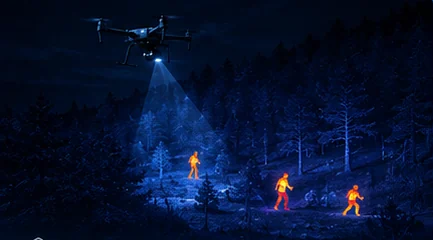
A wounded deer that would take a tracking dog hours to find shows up in a thermal drone’s first orbit — which is why deer recovery has become one of the fastest-growing thermal drone services in North America and Europe.
- 80–120 mWorking altitude with 640×512
- 640×512Class standard
- HoursHow long the signature persists
- Recovery onlyWhat the law usually permits
Key takeaways
- Blood trails fail in rain, water crossings and low-blood hits. Body heat does not.
- A deer-sized signature reads clearly from 80–120 m with a 640×512 sensor for hours after the animal beds down.
- A zoom or low-light channel is needed to confirm species and condition before guiding anyone in.
- Regulations vary sharply. Many regions permit recovery of downed game and prohibit using drones to hunt or harass live animals.
On this page
Why Thermal Beats Tracking on Difficult Recoveries
Blood trails fail in exactly the conditions where recovery matters most: rain washes them away, water crossings break them, and a low-blood hit may leave almost nothing to follow. A tracking dog is extraordinary and still working from a signal that the environment can erase.
Body heat does not wash away. A deer-sized signature reads clearly from 80–120 m altitude with a 640×512 sensor for hours after the animal beds down, and it is visible through the cover that makes ground tracking slow.
The altitude band matters because it sets search width. At 80–120 m a 640-class payload covers ground quickly while keeping the animal several pixels across — the same pixels-on-target arithmetic that governs any thermal search. A 256×192 core works under about 60 m but costs search width, which on a time-limited recovery is the binding constraint — the resolution comparison covers the trade.
The Recovery Workflow
A repeatable sequence beats improvisation, particularly in the dark with a hunter waiting.
- Start from the last known point and fly a spiral or lane pattern outward, with a downwind bias — wounded animals commonly move downwind.
- Mark every candidate signature with a coordinate before investigating any of them.
- Descend or slew the zoom channel to confirm species and condition — deer, not livestock or dog, and down rather than bedded and alive.
- Drop a pin and guide the hunter in on the confirmed animal.
- Log what was searched so a second sweep does not repeat the first.
Marking before investigating is the discipline that separates a productive recovery from a frustrating one. An operator who descends on the first contact and loses it has no record of where it was, and the search restarts — LRF-equipped payloads hand off exact coordinates directly, as the rangefinder guide covers.
Species and condition confirmation before guiding anyone in is both practical and ethical. A thermal signature is a warm shape; whether it is your deer, someone’s dog, or a live animal that will run when approached is a question only the visible or low-light channel answers.
Payload Requirements
Three requirements, and a fourth that is about the aircraft rather than the pod.
| Requirement | Why | Class standard |
|---|---|---|
| 640×512 thermal | Search width at 80–120 m altitude | MV-2P — 130 g, <40 mK |
| Zoom or low-light channel | Species and condition confirmation | MV-4X — adds starlight and NIR |
| Coordinate output | Handing a position to the hunter | LRF-equipped pods, 5–2,000 m |
| Quiet aircraft | Avoid pushing a live animal | Airframe choice, not payload |
The MV-2P and MV-4X are the class standards. The MV-2P covers the core requirement at 130 g with the most sensitive published NETD in the line — useful because a bedded animal in mild conditions is a lower-contrast target than people expect. The MV-4X adds the confirmation channels and ranging in one 366 g pod.
The quiet-aircraft point is genuinely important rather than a courtesy. A live wounded animal pushed by aircraft noise moves further and suffers longer, which is the opposite of what the service exists to do.
Rules and Ethics
Regulations vary sharply by jurisdiction, and this is an area where getting it wrong has consequences beyond a fine. Many regions permit recovery of downed game but prohibit using drones to hunt or harass live animals — the distinction being between finding an animal already shot and using aircraft to locate or drive one that has not been.
Know your local wildlife code before offering the service, not after a complaint. The rules are often held by a wildlife agency rather than the aviation authority, which means aviation compliance alone is not sufficient — you need permissions from both, and they do not talk to each other.
Fly recovery only, and confirm kill status before approach. An operator who finds a live, mobile animal should be ending the flight rather than following it, both because that is usually what the law requires and because pursuit causes exactly the harm the recovery was meant to limit.
Two regulators, not one. Aviation rules govern the flying; wildlife codes govern what you may fly for. Compliance with one says nothing about the other, and recovery operators need both.
The broader operating discipline — logging, retention and community relations — applies here too, and is covered in the privacy and regulation primer. Related thermal wildlife work is covered in wildlife monitoring.
What Changes the Odds
Timing dominates. Thermal contrast against the ground is strongest when the ground is cool, so evening and night recoveries generally read better than midday ones — and the animal’s own signature fades as it cools after death, which is the clock the whole operation runs against.
Cover matters next. Dense canopy blocks LWIR entirely, so an animal under heavy cover may be invisible from directly above and visible from an oblique angle — flying the same area from a second geometry is often what finds it.
And weather applies the usual discount: rain and fog attenuate, wind flattens contrast by cooling exposed surfaces. Fog, rain and humidity limits covers the atmospheric side, and cold-weather operations covers the season when contrast is best and batteries are worst.
Related reading
- Starlight and Low-Light Imaging
- 256×192 vs 640×512 Resolution
- DRI Ranges Explained
- Why a Laser Rangefinder Belongs on Your UAV Payload
- Search Patterns for Thermal Drone SAR
- Thermal Drones, Privacy and Regulation
- Cold-Weather Thermal Drone Operations
- Livestock Monitoring with Thermal Drones
- MV-2P — 640×512 thermal at 130 g
- MV-4X — thermal, starlight and ranging
- MV-2M — 110 g dual-sensor micro pod
- Wildlife Monitoring with Thermal Drones
FAQ
How long after the shot does thermal still work?
Hours, in most conditions — a deer-sized body retains enough heat to read clearly against cool ground well after it beds down. The signature fades as the animal cools, so the window is longest on cold nights and shortest in mild weather. The practical guidance is to launch as soon as it is safe and legal to do so rather than waiting for full dark, since the contrast advantage of darkness is often outweighed by the cooling clock.
Is 256×192 enough for deer recovery?
It works under about 60 m altitude but costs search width, and search width is what determines whether you cover the likely area before the signature fades. A 640×512 core lets you fly 80–120 m and sweep considerably more ground per battery. If recovery is an occasional favour, 256 is workable; if it is a service you charge for, 640 is the class standard for a practical reason.
What are the legal restrictions on drone deer recovery?
They vary sharply by jurisdiction and are usually set by a wildlife agency rather than the aviation authority, so aviation compliance alone is not enough. Many regions permit recovery of downed game while prohibiting the use of drones to hunt, locate or harass live animals. Know your local wildlife code before offering the service, fly recovery only, and confirm kill status before approaching or guiding anyone in.
Questions about the technology? Talk to our engineers — we reply within 2 business days.